PERAIA project
The project name
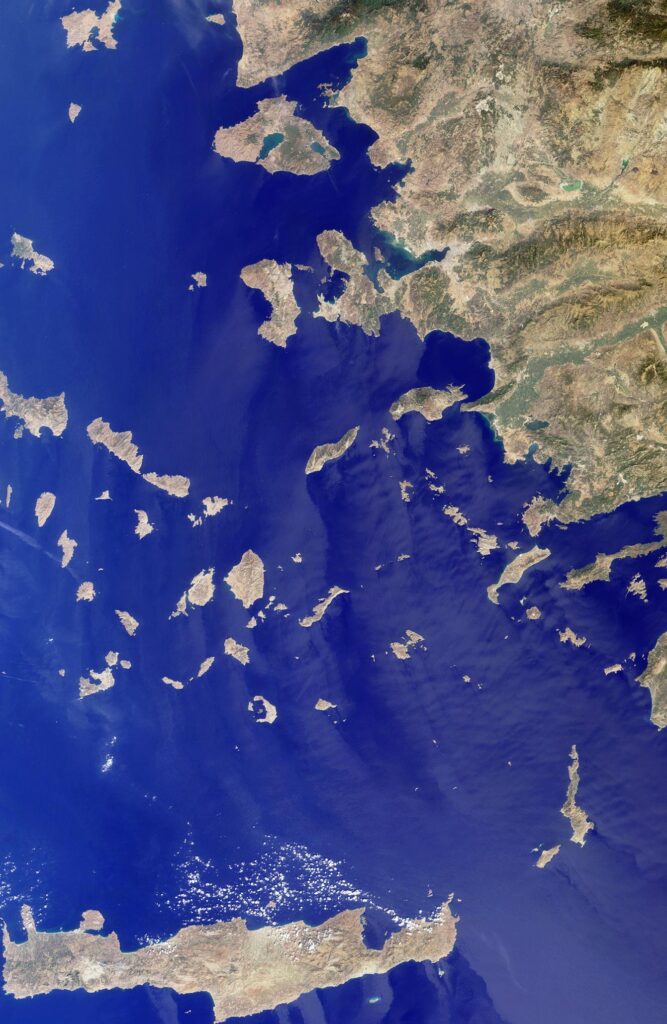
By the term “Peraia” (περαια) the ancient inhabitants of the Aegean geographically defined the territories beyond their boundaries, generally separated by the sea.
This term seemed to represent a duality: insularity versus continent; land versus sea.

The PERAIA project is designed to analyse and represent the social, economic and cultural impact of the historical networks of mobility and connectivity in the area of contacts between Crete and the Libyan-Egyptian coast, from the Late Bronze Age to the beginning of the Iron Age (c. 1600 – 750 BC). All this, from a methodological approach that integrates the use and processing of satellite imagery, network analysis (SNA) and GIS applied to spatial analysis.
Interdisciplinary approach
Research in Archaeology has experienced exponential growth over the last decades, mainly due to the influence of digital technologies and the fusion of different theoretical schools. Quantitative approaches from the Digital Humanities have opened up new possibilities for interpretation by combining techniques from other disciplines, such as Geography, Computer Science and Social Science, which allow for the development of new research methods.
Remote Sensing
Geographical Information System
Social Network Analysis
Objectives
The overall aim is to create a geospatial network model to improve the understanding of connectivity at different scales in the Eastern Mediterranean, from the Late Bronze to the Early Iron Age (c. 1600 – 750 BC).
- Identify and register the settlements and occupation phases of the coastal communities located in the Libyan Sea area during the (Pre)historical period.
- Reconstruct and analyse, in a diachronic and multi-scale approach, the transport network and settlement patterns among the regions located within the study area.
- Disseminate and make available research results both to the scientific community and to institutions involved in the protection of terrestrial and underwater archaeological heritage.
- Laying the foundations for the creation of an international collaboration network between researchers from different institutions interested in the topics under study.
Research methodology
In terms of research methodology, this project proposes an interdisciplinary approach, integrating specialists from different areas such as: information modelling, satellite remote sensing, Geographic Information Systems (GIS) and network analysis (SNA).
Information modelling. The development of an information model is the essential first step in designing a robust yet modular structure for the spatial database. The aim is to create a model adapted to the research questions of the project, to extend its inferential potential, and at the same time to take into account existing ontologies and published datasets.
Remote sensing. Identify settlements, archaeological structures and landscape units through photo-interpretation and processing of Landsat 8 satellite images, at a spatial resolution between 0.1 – 50 m depending on the scale of the study, recording their morphology, organisation and distribution within the territory and influence within the landscape.
Geographic Information Technologies and spatial analysis for the structured storage, management and processing of alphanumeric and spatial information. Using GIS software, we will georeference the locations by integrating geomorphological and hydrographic data. In addition, the GIS platform will allow us to combine archaeological and environmental data, and to work at different scales (macro, meso and micro) with spatial analysis tools applied to the study of the landscape.
Network analysis and map algebra. Using network analysis (SNA) we will reconstruct the model of the land and sea transport network among these regions. In addition, to represent the properties of the structure we will develop space-time-cost studies between settlements, together with flow diagrams to calculate the most efficient routes and show which ones were used depending on seasonality.

DAVID LAGUNA PALMA – IP
FPU fellowship at the University of Granada (Spain).
MAURIZIO TOSCANO – CoIP
ICT Higher technician at the European Office at the Spanish Foundation for Science and Technology (FECYT – Spain).

TOM BRUGHMANS
Professor of Classical Archaeology at the Center for Urban Network Evolutions at the University of Aarhus (Denmark).

BORJA LEGARRA HERRERO
Lecturer in Comparative Mediterranean Prehistory at the Institute of Archaeology, University College London (UK).

PAU DE SOTO
Marie Curie Fellow at the Universidade Nova de Lisboa (Portugal).